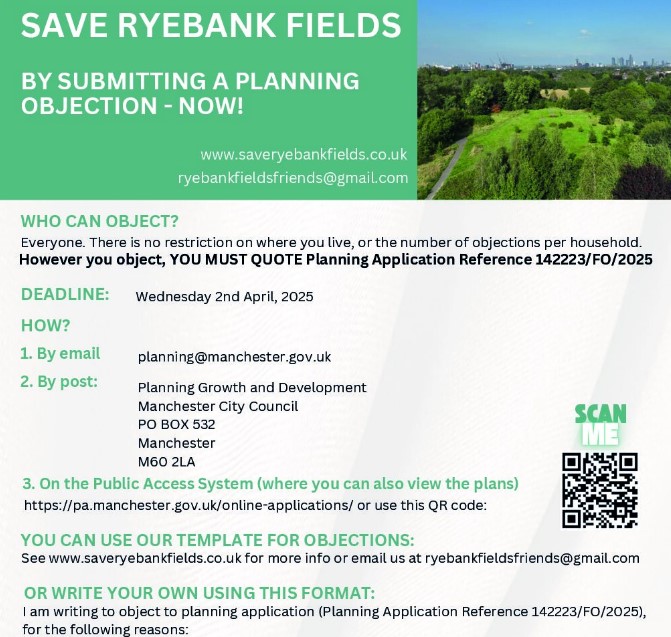
There are two planning applications relating to this proposal. The main one is to Manchester 142223/FO/2025 and there’s a second to Trafford 115688/FUL/25 for the North access road from Rye Bank Road in Stretford. The deadlines were 5th April and 26th March, at this point it is not clear whether they are still registering any comments.The paperwork supporting them is identical. We are advising people to log their objections to Manchester first, then to copy or forward by email that same objection ‘in principle’ to Trafford, with extra wording as to why you object to an access road into Firswood being built over the Rye Bank Road Community Garden.
IMPORTANT – YOU MUST INCLUDE YOUR NAME, ADDRESS, AND THE PLANNING REFERENCE NUMBERS FOR YOUR OBJECTION TO BE LOGGED
For email (send to planning@manchester.gov.uk and development.management@trafford.gov.uk ) or letter template, click here.
You can also submit your objection to Manchester and Trafford via their Planning portals using the links above – but beware it can ‘time out’ so we advise to prepare your response elsewhere then cut and paste it.
An objection in your own words is much more powerful, so click here for ideas!
Your comments WILL NOT be displayed on the Manchester Planning Portal until 5 days before the Planning Committee meeting, so if you are happy for them to be shared in advance in public (without your name but with road and/or postcode) please ALSO copy in ryebankfieldsfriends@gmail.com and your local councillors and we will try to make them viewable.
For a copy of our latest leaflet to share with friends and colleagues, click here
Email and Letter Objection Template – to Manchester Council
Click here for Template text to copy and paste – NB not formatted
[please feel free to add your own words, pictures or photographs, personalise with examples of how this issue already does or would affect your daily life, or delete any sections that do not resonate with to you.]
[YOUR Name]
[Address- include postcode]
[Date]
To whom it may concern,
RE PLANNING APPLICATION – RYEBANK ROAD Planning Application Reference 142223/FO/2025
I am writing to you to OBJECT to the above application for development on Ryebank Fields, for the following reasons:
1) Loss of an irreplaceable Greenfield nature space. Manchester Council should not approve the destruction of a semi-natural rewilded space to be destroyed, when there are decades worth of Brownfield sites yet to be developed within walking distance in Chorlton, Old Trafford and Stretford. The Manchester Core Strategy highlighted the deficit of natural and semi natural green spaces in the south of the city over a decade ago, and Manchester Council’s own Housing Land assessment identifies double the amount of brownfield land in Manchester required to meet government targets for housing need.
2) Amenity and importance to the community. Around 25,000 residents live within a 15 minute walk of Ryebank Fields (with this number set to increase significantly). Thousands of those people support the campaign to Save Ryebank Fields. The Local Plan consultation in 2020 received an overwhelming response from 100s of residents that Ryebank Fields should be protected as a Local Green Space, and council officers agree that it meets the required criteria of being ‘demonstrably important to the local community on the grounds of its beauty, history, recreation, tranquillity, and wildlife value’. The plans also propose building a road over the much loved and well used community garden at Rye Bank Road. The garden was built by residents and is registered as an Asset of Community Value.
3) Traffic and road safety. The roads at the South end of Ryebank Fields are narrow, very long, and become very congested at peak times – especially school drop off/pickup, parkrun events and other athletic meets, football and cricket match days at Old Trafford. Cars park along each side of the roads, and on Longford Road this prevents vehicles or cyclists passing and causes frequent conflict and at times even angry scenes especially at school run time. St John’s Primary school is immediately adjacent to the Fields on one side and entrances to Longford Park on the other, and Longford Road is marked in the Chorlton Infrastructure Framework as a connecting cycle route to the ‘Busy Beeway’ which starts at that same Park entrance. Ward Councillors and council officers have explored solutions over the years but have been unable to implement them because of budgetary and logistical constraints. Traffic worsening at peak times would increase the existing risks and unpleasantness for pedestrians, including children in buggies, and cyclists.
4) Air pollution. The streets surrounding these Fields are already above the 85th percentile for pollution in the UK and exceed multiple WHO air pollution limits. A development on Ryebank Fields would result in increased congestion on these long narrow roads and worsen this issue, whilst reducing the vegetation which has a mitigating effect. This is concerning for residents and for parents of the children who attend the two nearby schools of St John’s and Oswald Road. There is also concern that the process of development would unearth and expose toxic gas, dust, and other hazardous materials.
5) Heritage. The historic Nico Ditch, elsewhere in the City registered with Historic England as a scheduled monument, is believed to run through the fields, its importance was even recognised in the 2017 Development Framework for Ryebank Fields. The proposals do not fulfil the requirements to ‘enhance the Nico Ditch’ but instead will destroy it.
6) Flooding. Houses and leisure areas near Ryebank Fields are already subject to flooding when there is heavy rainfall. Ryebank Fields provide a natural flood defence, and I am concerned that the large scale removal of this flood sink will worsen this existing issue.
Please acknowledge this submission and let me know where it will be logged for future reference.
[Insert name]

‘How to Object’ leaflet to download and share
Write your own objection
Below, and linked here are outline ideas of points to include for each of the main ‘material considerations’ that Planners take into account. You can pick as few or as many as you like, it’s best to separate them clearly in your response with bullet points or headings. (there are others – see here for more ideas)
We have provided some reference documents with more facts and figures and policies to quote in the google drive we have set up specifically for this purpose. But you can keep it really simple too, just a couple of sentences from your experience about why you care, with examples if you have them, or even photos – and try to relate it to the material considerations if you can – here are some examples taken from other people’s responses.
You may wish in the meantime to look at our own Ecology Report and our comments on the previous consultation‘s ‘eco-credentials’
Planning Policy including protecting Greenfield
• Manchester has a Brownfield-first policy; Ryebank Fields is classified by Manchester City Council as Greenfield
• Manchester has double the amount of Brownfield land needed to meet housing targets
Biodiversity
• Rewilded thriving ecosystem
• Variety of habitats – woodland, scrub, grassland
• South Manchester is a nature depleted area
• Ecology report shows there will be a 40% loss of biodiversity on site
• Manchester’s Biodiversity Strategy states that 98% of respondents to its consultations said they were concerned about the loss of wildlife in Manchester
Protected and vulnerable species
• Bats, badgers, hedgehogs, bird species of conservation concern
• Ryebank Fields is home to priority species – bats, swifts, Black Poplar trees, hedgehogs, toads, willow tits
Trees
• Fields currently act as a carbon sink
• Extensive invasive works in relation to the Thirlmere Aqueduct means there is likely to be extensive damage to the root system of the Aspen Grove, which is rare in Manchester and locks up and stores double the amount of carbon of other trees
• Eastern woodland boundary and silver birches at south end will be lost
• Loss of some of the Millennium oaks, a special feature of the fields
Loss of Local Amenity
• 25,000 residents live within 15 minute walk of the fields
• Much-loved and well used by the community for children playing, nature connection, dog-walking, walking route between Chorlton and Stretford
• Many community events take place – e.g. women’s walks, carols, bat-watching, guided walks, singing sessions, wassails, children’s nature craft events, children’s trails, community meetings, therapy sessions
• RF is important to the community because of its wildness, natural beauty, tranquility, history (Nico Ditch), recreation
• Ryebank Road Community Garden would be lost
Impact on Heritage
• Nico Ditch – the plans would build over and obliterate a section of this potential ancient monument, a mediaeval or possibly Anglo Saxon boundary marker that spans the City
• Longford Conservation Area – Paths, lighting and rooflines from the development would impact on the views and relaxed timeless setting (including sounds) of the heritage lottery award winning Park.
Traffic and Road Safety
• Proposed development could add 240 cars to local roads
• Extra cars created by the development would further endanger vulnerable road users – children, pedestrians, cyclists – at school run times, which are already very congested and dangerous
• Local roads are also very congested due to the proximity of Longford Park Stadium – eg an average 700 people take part in weekly Parkrun events there
• The development is next to an entrance to Longford Park, which would cause further road safety issues
• Longford Road residents have already had several instances of contact with councillors re congestion currently
• More cars and the loss of vegetation on RF would worsen the air quality around the park and St John’s Primary School; Manchester already has some of the worst rates for children’s emergency admissions to hospital for respiratory conditions in the UK
Flooding and Drainage
• There are already issues with flooding of properties in the surrounding area and Longford Park; hard landscaping on the fields and loss of vegetation will mean more flooding for local properties
Pollution and Air quality
• Impact on air quality in local neighbourhood and St John’s playground while building work is done (estimated two- three years)
• Continued impact of air pollution caused by more vehicles and loss of trees and vegetation which mitigate it
• Light pollution will have a detrimental impact on wildlife, especially if paths and lighting are placed in woodland area
• Concerns about disturbance and release of new of toxic materials into soil and water and the potential impact of transportation of toxic landfill materials on local schoolchildren and residents
Loss of Privacy, Overlooking, Overshadowing/Loss of light
NE and East edges
Previous Planning Decisions
Planning for housing refused in 1996, on appeal was also refused. In 2005 MCC advised MMU Planning would not be granted as there was no evidence of local need, MMU chose not to pursue at that point
Contaminated Land, Hazardous Materials, Ground Stability.
Concerns of risk of disturbance and release of new wave of toxic materials into ground, water, ecosystem, and air
MORE INFORMATION TO FOLLOW
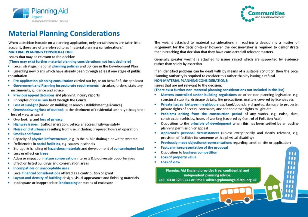
Material planning considerations – more info
Manchester City Council is legally obliged to make its decision based on specific Planning grounds known as Material Considerations. Strength of public feeling is taken into account, but it makes a much stronger case to include material considerations in any objections: